NGULIK BANDUNG: History of Situ Aksan, Bandung's Lost Lake
The sweet story of the lake where Bandung residents rejoiced has come to an end. The beauty of Situ Aksan has now turned into a very crowded settlement.
Penulis Merrina Listiandari23 November 2023
BandungBergerak – Situ Aksan... Situ Aksan, Pelesiran jeung lalayaran. Andom Suka seuseurian, sempal guyon jeung gogonjakan. Situ Aksan… Situ Aksan, keur panglipur manah sungkawa, tempat sirna pangbebenah nu nandang lara asmara. The lines are from a popular song by Mang Koko, a Sundanese cultural figure, which tells the story of a popular tourist spot in Bandung in the past, Situ Aksan.
It's not just a song, even testimonies from people who spent their teenage years in Bandung in the 60s can still be heard today. In accordance with the meaning of Mang Koko's song fragment above, they said that Situ Aksan was a place for leisure, picnics and even a place to confess love for many young couples in Bandung.
However, the beautiful story of the lake where niis bari gogonjakan, which means a place to chill while making jokes, has come to an end. Now the area that used to be a lake is just a memory, with only a stretch of road between Suryani Street and Pagarsih Street left. What was once a huge lake has turned into a densely populated residential area.

Baca Juga: NGULIK BANDUNG: The Expressway between Bandung and Batavia
NGULIK BANDUNG: 100 Years of Bosscha Observatory, the Largest in the Southern Hemisphere
NGULIK BANDUNG: Buitenzorg, the First City to Cultivate Pineapple Fruit Typical of West Bandung
Not a Natural Lake
People often recognize Bandung as an ancient lake that was formed by the eruption of Mount Sunda in the Pleitocene period around 210,000 to 105,000 years ago. Not so surprising, many people believe that Situ Aksan is one of the many lakes that remain due to the deep basin of the ancient lake.
However, this is disproven when looking at ancient maps published by the Dutch colonial government. On the map of the Cinchona planting route in the Bandung area released in 1881, there is no lake in the legend or description of the meaning of the symbols on the map. The meer or lake symbol is only found in the Soekawana area, near Mount Tangkuban Parahu and further near Mount Wayang.
Likewise with the 1910 map of Bandung, the Sukahaji area, where Situ Aksan is located, at that time did not contain a single water area. But there is something different about this map, there are several new symbols in the area with the description Stb or steenbakkerij which means brick factory.
Until the 1921 map, the area that was later known as Situ Aksan in the map began to be marked with sparse shading at the edge of the land and had a description as drasland or wetland, suspected of being a pond or balong surrounded by steenbakkerij or red lio brick. Many people at that time referred to it as balong Aksan. The depiction of different symbols over the same area clearly shows that Situ Aksan is an artificial lake.

The Origin of the Naming of Situ Aksan
Just as many toponyms of a place or area in Bandung attribute the owner of the land or who first controlled the area to its name, so does Situ Aksan. Many stories say that the original owner of the land used as a situ or lake was a rice field owned by Haji Aksan, a large batik merchant in the city of Bandung, or known as Haji Aksan batikan. However, is this true?
I tried to trace data related to Haji Aksan from various written sources and found two names of Aksan as a businessman in Bandung at that time. In the book Gedenkboek vereeniging Himpoenan Soedara 1906-1936 published by A. C. NIX & Co. BANDOENG, Hadji Aksan is included in the list of batik wholesale merchants who were gathered in an association of traders called the Soedara Association.
Bandung became a center of trade, including the batik trade, which at that time was still controlled by bumiputera merchants. These merchants collected batik from Mataram, Solo, Pekalongan, Kaliwoengoe or Tanah Abang which they sold in their simple bamboo-pole houses by the roadside, which later became the forerunner of Pasar Baroe Bandung.
In addition to Hadji Aksan, there is another name listed as a businessman in Bandung who uses the name Aksan, namely Mas Aksan. This name was written about a lot in the local print media as a businessman whose reputation was taken into consideration. De Preanger Bode, August 24, 1911, announced that Mas Aksan and his Chinese colleagues had founded a company called Kalkbranderij Berg or Chalk Mountain. They were in the business of mining, exploiting and building lime kilns and trading it as building material.
Mas Aksan's name did not only make the news once or twice in relation to his work as a businessman. He was not only known as a chalk merchant, but also as a property entrepreneur. De Preanger bode, May 20, 1916, announced that the Commissie Voor Het Grondbejrift or Land Management Commission approved the request for the purchase of land at Grootepostweg and Tjikoedapateuh, near the train station, by Mas Aksan, the landlord of Bandung.
The story of land ownership above is linked to a later story in De Sumatera Post, June 24 of the same year, that Mas Aksan had made an important agreement with the Railway Jawatan to pay regular monthly rent for the wagons he used to transport lime to other cities.
The news of May 20, 1916 also answered the question of who owned the steenbakkerij or lio brick shown on the 1921 map of Bandung surrounding the drasland in the Sukahaji area, as well as the Westerpark (now Jalan Suryani and Jalan Pagarsih) next to Grootepostweg. Therefore, it makes sense that the name of Situ Aksan referred to Mas Aksan as the owner of the land as well as the owner of the property, trade and chalk processing business, which is also an additional material for making bricks.
In spite of the above data, the writer recently received confirmation from the fourth generation of the Aksan family. "It is possible that the two people mentioned above are indeed referring to the same person, because to the best of our family's knowledge, Aki sold batik at the beginning of his business, but then became successful when he became a businessman in chalk, lio brick, and building materials when Bandung was built by the Dutch East Indies government," he said.
The author has traced the records in the Gedenkboek Vereeniging Himpunan Soedara 1906-1936, where the name M. Roesdi Achsan (Roesdi Aksan) is written as an active person in the organization, and cross-checked in the Genealogical Association (Stamboom) of the Great Family of Pasar Baru Bandung, by Syamsuri, it is known that Roesdi Achsan, is one of the eight sons of Moch. Achsan, aka H. Aksan.
Therefore, both Hadji Aksan and Mas Aksan refer to two people in the same large family, the family of Moch. Achsan, a batik merchant who later succeeded as a lime entrepreneur and owner of many steenbakkerij or lio brick.

Peh Tjoen Water Festival
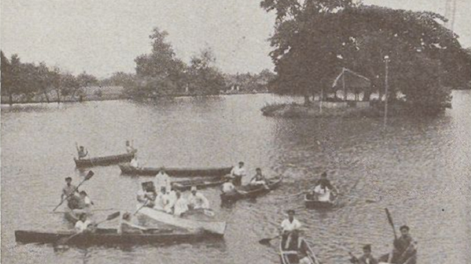
Initially the area was a drasland or wet area called a balong. As time went on, the balong grew into a situ or lake that utilized a sodetan on the Leuwi Limus river that flows next to the Westerpark that surrounds it. Gradually, this small lake became a gathering place for the residents in the neighborhood.
Not just gathering, even strikes of employees of the telecommunications company Nix & Co, which is the publisher of the Indische Telegraf, were carried out there. Bataviaasch Niewblaad, January 6, 1925, reported that the company's employees gathered at Situ Aksan while waiting for a decision on their fate.
As time went by, Situ Aksan became more and more frequented by people from the native community, Europeans and Chinese. Even the Chinese community has an annual routine agenda to carry out waterfeesten or the Peh Tjoen Water Festival.
Algemeen Indisch Dagblad, June 18, 1947, explained that this festival was held by the Chinese community to honor a hero from ancient Chinese history named Chuh Yuan (Koet Goan) or Ling Chun. Chuh Yuan was defamed and driven out of the kingdom by the emperor Tsing Siang Wang. Disappointed and saddened by his mistreatment, he immersed himself in the Pe Lo River in Yuan State.
After Chuh Yuan's death, the Sag Emperor realized the sincerity of the hero. So, to honor him, every 5th day of the 5th month of the Chinese Year, they hold an event by the river called Peh Tjoen, which in Bandung is routinely held at Situ Aksan every year.

The Government's Role in Building the Artificial Lake Situ Aksan
The Peh Tjoen Waterfeesten at Situ Aksan is apparently an annual festival that the people are waiting for. Various activities such as rowing competitions, pole climbing, swimming competitions, fishing, and even krontjong competitions attracted the attention of residents (De Korier, June 4, 1932).
Every year the water festival was held with bigger and more festive activities. Even Algemeen Indisch Dagblad: De Preanger Bode, June 22, 1955, reported that the Peh Tjoen Waterfeesten that year was held on a large scale with lion dance and wayang golek performances because it coincided with the Idul Fitri holiday.
Situ Aksan's potential to attract local tourists eventually attracted the attention of the government, which was aggressively developing Bandung. They collaborated with N. V. De Eerste Nederlandsch-Indische spaarkas (Dutch East Indies Savings Bank)-abbreviated as N. V. Denis-to build and develop the area.
The government along with N. V. Denis wanted to turn the Djamikaweg, Westerpark, and Sitoe Aksan areas into a villapark, a simple housing estate with cheap installments that had a real estate concept and luxurious facilities with a beautiful lake (Mooi Bandoeng No.3, March 1939). Thus, the "Roro Jonggrang" project was implemented synchronously and on a large scale.
Under the direction of Ir. Poldervaart, 150 houses were built in a beautiful row. The usually muddy roads were neatly paved, the plants that made the westerpark look sareukseuk were uprooted, trimmed and tidied up; luxurious restaurants with burning lights would stay open until one o'clock at night, being one of the luxurious facilities built in Situ Aksan.
Most importantly, the project employed diggers who were instructed to enlarge and deepen the lake, which would become an artificial natural recreation center that could be enjoyed by all Bandung residents (Mooi Bandoeng, vol.8, February 1940). This record is also written evidence that Situ Aksan was not a natural lake.
That's how Situ Aksan once served its function as the main recreational area in Bandung at least until the 1970s. An artificial lake that depends on the Leuwi Limus river flow as its main source of irrigation, Situ Aksan had to succumb to the dynamic growth of Bandung's population. Situ Aksan dried up, the water was replaced with buildings that grew like mushrooms after the rain. The history of Situ Aksan was finished.
* Translated from this article by Khumaira Birru Al Walidain.