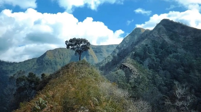
MOUNTAINS IN GREATER BANDUNG: Mount Sangar Arjasari, Small and Beautiful at the Foot of the Malabar Mountains
Mount Sangar Arjasari was once known as a frightening and eerie location. Nowadays, it has become a popular tourist destination in southern Bandung.
Penulis Gan Gan Jatnika13 September 2023
BandungBergerak.id - A small mountain at the foot of the Malabar Mountains, Bandung Regency, has an interesting look: it resembles an upside down half-circle. It isn't particularly tall, but it still manages to pique people's interest to learn more about it.
The name of this mountain is quite unique, namely Mount Sangar. The word "sangar" means "frightening" in Indonesian and Sundanese. On page 606 of R. A. Danadibrata's Sundanese Basa Dictionary, the word "sangar" refers to a character or trait which brings about troubles or harm. In ancient Tatar Sunda, a place known to bring accidents or a feeling of unease to its owners was called the "Land of Sangar".
Such a scary meaning! So then why is this mountain in Arjasari, Bandung Regency, named Mount Sangar?
This is why toponymy is essential. Toponymy has two meanings, according to the KBBI (Great Dictionary of the Indonesian Language). The first definition of toponymy is a branch of Onomastics that studies the names of places. The second definition of toponymy simply means the name of a place. Onomastics itself is the science of names and their origins. In a sense, toponymy is the knowledge of the name of a place, region, or any other part of the earth's surface.
According to locals the writer met in August 2021, the name Mount Sangar derives from the state of the mountain area and its forests, which are regarded as frightening and eerie. Frightening because of the many dangers that visitors may encounter, particularly wild and ferocious animals, and eerie because of the many mystical phenomenons that have become tales. As a result, very few locals dare to enter the area.
In the past, the horror and terror of the Mount Sangar forest were frequently associated with the legend of the king of the jungle: tigers. Not only are there myths about real tigers, but also about fictitious tigers. One of the stories, called Legoksura, can be found in the Baros area. The name "Legoksura" comes from the story of Pak Sura, who was killed by a tiger.
Location and Access
Mount Sangar is administratively located in Mekarjaya Village, Arjasari District, Bandung Regency. Mekarjaya Village was only established in 1983. This region was previously still part of Baros Village.
To get to Mount Sangar from Bandung City, we can take the route towards Banjaran. Before reaching the Banjaran T-junction, we head east towards Arjasari. The journey then continues onwards to the route to Baros, following the signs to the Yasmin tourist site. That's how we'll eventually reach Kampung Citiis or Kampung Pasirbentang, Mekarjaya Village.
The appearance of Mount Sangar can be seen clearly from Mekarjaya Village. To the west, the other peaks of the Malabar Mountains can be seen. There's the Malabar Peak, which is known for the presence of the Pedang Stone on its ridge. There are also other peaks, including Mega Peak, Reregan Peak, Ipis Peak, and others.
Mount Kolotok, which is nearly the same height as Mount Sangar, is located to the east of it. According to the RBI (Rupa Bumi Indonesia) map issued by the BIG (Geospatial Information Institute) edition 1 year 2000 with a scale of 1:25,000, Mount Sangar peak is 1,690 meters above sea level (MASL).
According to an old map created in 1893 and collected by the Leiden University Museum in the Netherlands, there is the name "Djaya'' on the west side of Mount Kolotok. It could be that Mount Djaya is the old name of Mount Sangar.
From the heights of Mount Sangar flow several clear springs. These springs eventually form several small rivers that flow into the Ci Bintinu River.

Tourism and Economic Potential
According to an old map created in 1893 and collected by the Leiden University Museum in the Netherlands, there is the name "Djaya'' on the west side of Mount Kolotok. It could be that Mount Djaya is the old name of Mount Sangar.
Mount Sangar is no longer as frightening or eerie as it once was. The mountain at the foot of the Malabar Mountains is now a beautiful area with an excellent tourist attraction.
The base camp from which you can start hiking is already available and easily accessible. Its location is on Citiis Road, directly across from a mosque. The entrance fee for hiking is 5,000 rupiah, and the parking fee is 10,000 rupiah. Don't forget to also fill in the guest book that has been provided.
There are numerous natural wonders to discover on the hike to the peak. A large stone, about 300 meters from the summit, is among them. This stone is known as the Susun Stone.
The view from Susun Stone is spectacular. Looking north, one is able to see the urban expanse of southern Bandung and the Baleendah Mountains clearly.
There is also Korsi Stone, Table Stone, Kantil Stone, Tumpeng Stone, and other stones in addition to Susun Stone.
In addition to the charm of its natural tourism, Mount Sangar also has an impressive football field known as the Pasirbentang Football Field. It derives its name from its location in Kampung Pasirbentang. The peak of Mount Sangar and other peaks in the Malabar Mountains are also visible from this field.
Another feature that distinguishes the Pasirbentang Football Field is the presence of a Waru tree tilting forward on the south of the spectator stands. It tilts so far forward that its trunk almost touches the ground.
The potential for plantations in this area is also exceptionally great. There are plantations of vegetables, pine, and coffee. Coffee plantations' produce has been appropriately managed and manufactured under the brand name "Sangar Coffee." If you don't have time to enjoy this local coffee while you're there, you can take it home as a souvenir.

Problems and Risks
The Mount Sangar area is prone to forest fire disasters, particularly during lengthy dry seasons. This is due to the presence of lush reeds in the majority of its areas.
The large fire that occurred in October 2019 is proof of this. Tens of hectares of land in the Mount Sangar area caught fire at the time, and the fire spread fast to other parts of the Malabar Mountains, including the Mount Puntang area. The steep and treacherous terrain made it difficult for firefighters to reach the area, resulting in difficulty controlling the fire. It took several days to extinguish.
Visitors to Mount Sangar are advised to exercise caution when lighting a fire for a bonfire or cooking while camping. Before leaving, visitors must ensure that the fire is completely extinguished. The same goes for smokers. Throw away cigarette stubs with caution, especially if the ends are not completely extinguished.
*Translated from this article by Maureen Amara Prasetyo (SMA Santa Angela Bandung)