NGALEUT BANDUNG: Exploring Pangaritan in East Bandung
The name Pangaritan comes from the area where people harvest hay to feed cattle. Now this area in eastern Bandung has been replaced into a residential area.
Penulis Alex Ari14 November 2023
BandungBergerak.id – The Pangaritan area in east Bandung is located between Jalan Sukarno-Hatta and Jalan A. H. Nasution in Ujungberung, Bandung City. This area shows how important domestic animals were to transportation in Bandung.
Haryoto Kunto in his book Wajah Bandoeng Tempo Doeloe (1984) contains a map of “District Oedjoengberoeng Kidoel” based on information from F. de Haan’s book Priangan: de Preanger-Regentschappen onder het Nederlansche bestuur tot 1811 deel I (1910). The map shows an area called Pangaritan on the east side of Moeras Geger Handjoeang.
Muras Geger Hanjuang is a vast swamp in eastern Bandung with its northern boundary being around the Cicadas area, its western boundary being around the Binong area, its southern boundary the Citarum River, and its eastern boundary the Pangaritan area. This swamp was once famous as a haunted area full of spirits.
It was only during the reign of Bandung Regent R. A. Wiranatakusumah IV (1846-1874) that several areas in the Muras Geger Hanjuang swamp area were awarded to a malim from the Limbangan area of Garut named Jaluddin for his services in repelling the spirits in the great work of straightening the Cikapundung river. Jaluddin, who had studied religion as far as Surabaya, East Java, was considered to have a spiritual knowledge that enabled him to ward off various kinds of spirits. He became famous as Mbah Malim. Before settling in Babakan Surabaya, Mbah Malim had lived in the Rancaloa area, Gedebage, which is part of the Muras Geger Hanjuang swamp.
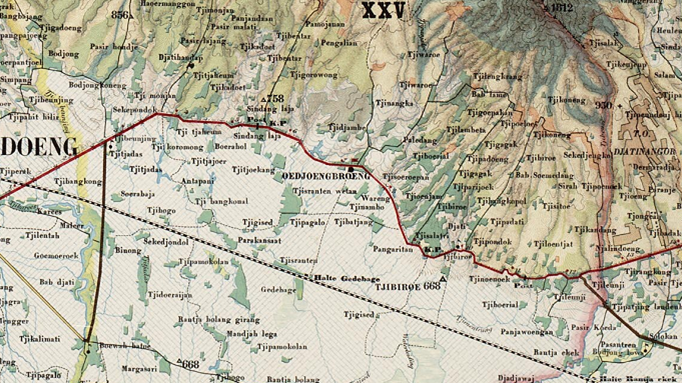
Information about the Pangaritan area was also found on an 1894 topographic map in the collection of the Leiden University library, the Netherlands. On this map, the location of Pangaritan is between the Gedebage bus stop and Ujungberung, while a large swamp area is located in the southern part under the names Rawah Luwar and Rawah Mundjul. The old condition of the Bandung area as a former inundation of ancient lakes has indeed left many natural formations such as lakes (situ) and swamps.
Information about the Pangaritan area was also found on an 1894 topographic map in the collection at library of Leiden University, Netherlands. On this map, the location of Pangaritan is between the Gedebage bus stop and Ujungberung, while a large swamp area is located in the southern part under the names Rawah Luwar and Rawah Mundjul. The old condition of the Bandung area as a former inundation of ancient lakes has indeed left many natural formations such as lakes (situ) and swamps.
Baca Juga: NGALEUT BANDUNG: Bung Hatta in Bandung
NGALEUT BANDUNG: Jenny’s Elegy at Gambung Plantation
NGALEUT BANDUNG: Association of Javanese Fellowship in the Land of Sunda
The Meaning of Pangaritan
In Kamoes Basa Soenda (1948) compiled by R. Satjadibrata and published by Bale Pustaka, the word ngarit means to cut grass using a sickle. As explained in the book Kandaga Tata Basa (1962) written by R. Momon Wirakusuma and I. Buldan Djajawiguna, the word ngarit affixed with the prefix pa- and suffix -an can be interpreted as a place where people cut grass using sickles.
Meanwhile, the word arit or sickle in some Sundanese dictionaries is mentioned as a tool for cutting grass. In addition to this main function, according to the Ensiklopedia Sunda: Alam, Manusia, dan Budaya (Termasuk Budaya Cirebon dan Betawi) (2000), the sickle has another function, namely as a tool for cutting rice during harvest. This happened especially when Sundanese people began to recognize new seeds of rice with shorter physical forms of plants and grains and were planted in rice fields.
Harvesting short rice plants will be easier to do using the sickle because of the bent position of the body. This is different when people in the western part of Java still plant old types of rice seeds with tall plants that are usually harvested using étèm or ani-ani.
The planting of new types of rice seeds and the use of sickles to cut rice has reduced the sacred beliefs of the Sundanese community in the form of respect for the rice plant from before to after harvest.
Still according to the Ensiklopedia Sunda: Alam, Manusia, dan Budaya (Termasuk Budaya Cirebon dan Betawi) (2000), the sickle is used mainly to cut grass for fodder.

Special Role of Farm Animals
In the past, farm animals played a special role in Bandung. Horses and buffaloes were widely used as a way of transportation on the Great Post Road (Groote Postweg). In Priangan, the route of the Post Road passes through difficult mountainous terrain. To be able to pass this route, horse-drawn carriages usually needed the help of buffaloes.
The business of providing animal supplies for transportation purposes, especially on the Jalan Raya Pos, is a promising business field because after a certain distance, usually the animals pulling the train must be replaced by fresher animals. One of the businessmen in this livestock supply business was Munada, a Chinese man who was behind the riot that caused the destruction of Ciguriang Market in Bandung in 1842.
In addition to being used as a means of transportation, farm animals in the early 19th century were also used as a means of paying zakat. According to Andries de Wilde, a landlord in Bandung, when it came time to pay zakat, wealthy farmers who owned buffaloes would pay their zakat in the form of zakat munding (buffalo). The buffaloes that would be paid as zakat would usually fill the public square in front of the Great Mosque of Bandung.
Because farm animals had an important role in the lives of people at that time, of course, good maintenance was needed, including the provision of feed (grass). It is not surprising that in the past there were areas where animals were grazed or called pangangonan and also where people used to cut grass called pangaritan.
One such place is the Pangaritan area in eastern Bandung. But now the land in Pangaritan has changed into a residential area. The story behind its name was gradually forgotten.
* Translated from this article by Altaf Hasna Banafsaj.