MOUNTAINS IN GREATER BANDUNG: Mount Manglayang, Blessings of Sanctity and Beauty that Towering in Eastern Bandung
Towering in eastern Bandung, Mount Manglayang presents beauty and sanctity. This area also provides clean water for many residents in the Bandung basin.
Penulis Gan Gan Jatnika14 September 2023
BandungBergerak.id – As we look northeast from the city of Bandung, West Java, Indonesia, we will see a charming array of mountains. Some are towering with peaks that seem to touch the clouds, some look tiny, and some look elongated like a natural fortress. Perhaps many Bandung citizens don't pay much attention to these mountains. When asked the names of the mountains, only a few of them can answer.
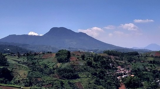
Of the many mountains in eastern Bandung, there is one that is clearly visible and larger than the others. It also has a distinctive shape with one main peak and a small peak to the east. The mountain is known as Mount Manglayang. This mountain can be seen from almost any direction in Bandung City.
The height of Mount Manglayang according to the latest Rupa Bumi Indonesia map issued by the Geospatial Information Agency is 1.827 meters above sea level (masl). However, it is more commonly known with an elevation of 1.818 masl. Perhaps due to the aesthetically pleasing digits, making it easier to remember. Also, administratively, Mount Manglayang is located on the border of Bandung Regency and Sumedang Regency in West Java.
Baca Juga: AN OPEN LETTER TO KING WILLEM-ALEXANDER: Is It True that the Three Muller Brothers Are Relatives of the Dutch Royal Family?
Dead End: How Christians Continously Being Denied to Build Church in Bandung Regency
MOUNTAINS IN GREATER BANDUNG: Mount Sangar Arjasari, Small and Beautiful at the Foot of the Malabar Mountains
The Origin of Manglayang Name
The name of Mount Manglayang is said to come from the word “melayang” (flew). One version tells that there used to be a horse that could fly, belonging to a pair of powerful figures, namely Prabu Eyang Layang Kusumah and his wife Eyang Layang Sari. Once upon a time, the horse had an unfortunate experience and fell on this mountain. Most of its body fell into the mud, with only the neck and head visible. The story of this flying horse is closely related to the myth of a rock that resembles a horse's head, so it is known as Batu Kuda. Those who are curious about this rock can visit it by walking approximately 700 meters from the gate of Batu Kuda Campground.
Another version says the word "Manglayang" comes from the plug of the ancient Bandung Lake. When Sangkuriang failed to fulfill the challenge from Nyai Dayang Sumbi to build a lake and a boat in one night, Sangkuriang was upset. He went to a place known as Sanghyang Tikoro on the Citarum River, pulled out the plug, and threw it to the east. The plug floated far away and when it fell, it became a mountain. Then, the mountain was named Manglayang.
Of course, all of these stories are just myths that enrich our cultural treasures. From every folklore circulating in the community, there are learning values that contain useful meanings. Nowadays, it is unlikely that anyone would believe that Mount Manglayang was once a water plug for the Citarum River. People would be more likely to believe in a scientific source that is more logical.
Mount Manglayang is known to have been formed due to a long period of volcanological and geological activity. In fact, it may have taken millions of years to form. As a mountain categorized as strato-shaped or layered, the formation of its layers resulted from multiple volcanological activities. The tendency for Mount Manglayang to have erupted in the past can be seen from the shape of the caldera on the western side, bordering the nearest mountain, Mount Pacet.
According to the people at the foot of Mount Pacet, there used to be a lake at the bottom of the caldera between the two mountains. There was even a tradition of "bathing the cat" for certain purposes in the lake. However, the lake no longer exists, having transformed into a forested and cultivated area by the residents. If you want to see the caldera and the rest of Manglayang Lake, you can climb to the top of Mount Pacet, which has an altitude of around 1.666 meters above sea level.

Beauty and Sanctity
The lushness of the forest and the fresh air make Mount Manglayang a worthy choice for a tourist destination. Inviting family, relatives, and friends to visit this place will surely not lead to regret. There are several places that can be visited, including the camping and nature tourism area of Batu Kuda, as well as Cilengkrang Waterfall. Equally intriguing is the relatively new tourist location which is Tangga Seribu (Thousand Steps).
Facilities at the tourist sites in the Mount Manglayang area are also quite good. Stalls, prayer rooms, and toilets are available.
Adventure enthusiasts can also consider Mount Manglayang as an option. Hiking or mountain climbing activities usually follow two main routes: Batu Kuda and the Baru Beureum Route. Some choose to complete the journey in a single day, while others opt to spend the night by setting up tents at the peak or camping area.
Moreover, some take a shorter hiking route with the goal of reaching one of the peaks along the mountain ridge. This location is called Bukit Papanggungan. From Bukit Papanggungan, you can witness the view of Bandung City, and if lucky, experience the beauty of the sunrise enveloped in mist that resembles an ocean of clouds. It's truly delightful to be in this place, especially while enjoying a warm beverage, be it tea, coffee, milk, or any other drink.
In addition to its beauty, Mount Manglayang is also known for its sanctity. Mount Manglayang is considered suitable for those seeking tranquility and embarking on a spiritual journey. It is not surprising that Mount Manglayang has long been regarded as a sacred place. "Kabuyutan" a Sundanese term, carries the meaning of a consecrated place and serves as a center for disseminating religion or belief in time.
Centuries ago, specifically around the 15th century, a nobleman from the Pakuan Kingdom embarked on a spiritual journey around the island of Java. This nobleman, known as Bujangga Manik, journeyed in search of knowledge and experiences to strengthen his devotion. He undertook this journey not just once, but twice. His travels extended not only to the edge of Java but also across to the island of Bali.
Bujangga Manik documented this journey in great detail: where he visited, which mountains he climbed, which rivers he crossed, and which kingdoms he encountered were all recorded in writings on pages of Nipah palm leaves. Unfortunately, this valuable work has been preserved far from his homeland since the 1620s, specifically in the Bodleian Library at the University of Oxford, England, under manuscript code MS. Jav.b.3 (R).
Bujangga Manik actually stopped in the eastern Bandung Mountain area as well. He wrote the following about his experience:
"Sadiri aing ta inya, leu(m)pang aing ngaler barat, tehering milangan gunung, itu ta Bukit Karesi, itu ta Bukit Langlayang, ti barat na Palasari." (When I went there, I headed northwest as if counting the mountains, that is Mount Karesi, that is Mount Manglayang, and to its west Mount Palasari.)
Bujangga Manik's writings accurately correspond to the position of Mount Manglayang, which is close to Mount Palasari. The small peak referred to as Mount Karesi is located above Pasir Leumahneundeut within the same region. This conclusion is based on observations made during the Napak Tilas journey following Bujangga Manik's route, in collaboration with the Wallagri community, traversing the eastern Bandung region, especially the Sundapolis area located in Ujungberung and its surroundings.
Wallagri is one of the communities dedicated to Sundanese culture and environmental conservation. During the Napak Tilas activity, the Bujangga Manik route was reconstructed based on data and information gathered from studies and various supporting sources. After careful analysis, a route outline was established, including an estimation of Bujangga Manik's position when observing Mount Manglayang. From the desired viewpoint, three of the mentioned mountains are distinctly visible in a row.
Water Sources and the Threat of Exploitation
Another natural wealth of Mount Manglayang is its abundant water sources and rivers. There are rivers such as Ci Beusi, Ci Panjalu, Ci Waru, Ci Hampelas, Ci Manyahbeureum, and several others. This clean water is the main source for locals to meet their daily needs by refilling water gallons.
This business is prevalent everywhere, from the roadside to small alleyways in densely populated settlements. Take a look at the trucks that arrive with "Mount Manglayang Spring Water" written on their tanks. Every day, these trucks shuttle back and forth, transporting water sourced from the base of Mount Manglayang.
This is undoubtedly a boundless blessing. However, behind this, we must also be cautious of potential negative consequences, especially if we neglect to preserve the environment. Overexploitation of these water sources and flowing rivers could potentially lead to disaster in the future. Landslides or floods could become a concern.
We certainly hope that such disasters will never befall us. This is true not only for Manglayang but also for other mountains in the Greater Bandung area.
* Translated from this article by Zelika Salsabila Insyra.