MOUNTAINS IN GREATER BANDUNG: Mount Sanggara, Enjoying the Riches of the Tropical Forest at the Ciung Wanara Heritage
Mount Sanggara is rich in unique flora and fauna of well-preserved tropical forest. The history of its naming is believed to be related to the legend of Ciung Wanara
Penulis Gan Gan Jatnika18 November 2023
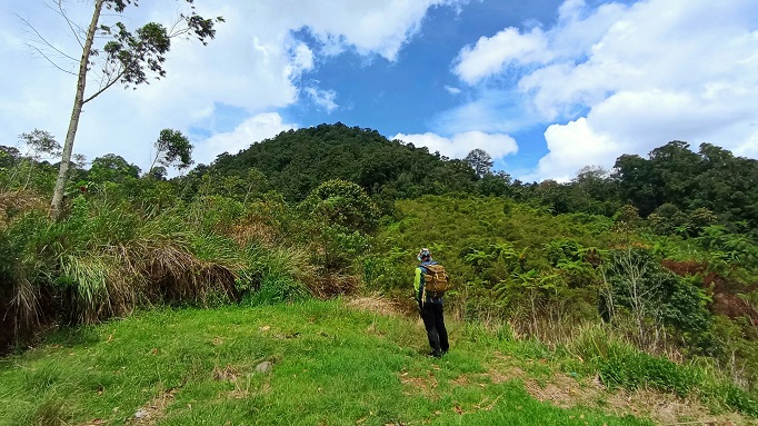
BandungBergerak.id - If you want to enjoy a journey in a lush forest, visiting Mount Sanggara is the right choice. The trails in this area are still natural with well-preserved humidity. Many leaves and flowers fall from the trees and scatter all around.
Location and Access
Mount Sanggara stands at an elevation of 1,903 meters above sea level (masl), referring to the RBI (Rupa Bumi Indonesia) sheet 1209-314, edition I-2001 with the title: Lembang, scale 1:25,000. From the city center of Bandung, it's approximately 20 kilometers to the northeast.
Administratively, Mount Sanggara is located at the border of Bandung Regency, Subang Regency, and Sumedang Regency. To reach it from Bandung, you can go through Pangli Village in Cipanjalu Village, then from Subang through Cupunagara Village, and from Sumedang through Genteng Village. The most popular route among these is the Pangli Village route.
Pangli Village was originally a settlement for employees of the Panglipur Galih cinchona plantation during the Dutch East Indies era. Established on February 3, 1833, this plantation was part of the Bukittunggul Cinchona plantation complex. What remains today, apart from the village itself, are the stone foundations. Referring to this history, it's highly likely that the name Pangli Village comes from a shortening of Panglipur Galih.
You can reach Pangli Village from Cibodas Lembang, passing through the Maribaya Tourist Area first. Alternatively, the journey can be made from Ujungberung Town Square, either behind it or to the north.
By utilizing online services like Google Maps, you can type in keywords such as Kampung Pangli atau Wisata Kina Bukit Unggul, then the map and directions will be provided.
Baca Juga: MOUNTAINS IN GREATER BANDUNG: Mount Mandalawangi, The Myth-Covered Mountain on the Border of Bandung and Garut
MOUNTAINS IN GREATER BANDUNG: Mount Sangianganjung (Sanghyang Anjung) Nagreg, the Remnants of the Kendan Kingdom Which is Rich in Obsidian Stones.
MOUNTAINS IN GREATER BANDUNG: Mount Selasih with the Unique Karut Stone, a Monkey Population and the Legend of a Princess
Ideal Location for Survival Training
The diversity of flora and fauna on Mount Sanggara makes this mountain often chosen as a place to practice survival skills in the wild. It is not surprising to find several areas in the form of fairly large plains that seem to be often used as shelter or camping areas (campgrounds) in the education and basic training activities of nature lovers.
The flora that grows in the forests of Mount Sanggara is diverse, ranging from ferns, bird's nests or cadaka, nangsi, saninten, begonia, cucumbers, to ki sireum which can be used as a food source. Another flora has long and wide leaves such as bananas, honje, and bingbin that can be used to create a shelter or emergency shelter. In the world of adventure, this emergency place is commonly called a bivouac.
No wonder then that the forest area on Mount Sanggara is known as the Survival Park.
Meanwhile, the fauna that lives in the Mount Sanggara area includes wild boars, long-tailed monkeys, langurs, deer, squirrels, civets, eagles, julang, and leopards.

Steep Ascent to the Peak
Many people choose to begin their ascent to Mount Sanggara from Pangli Village, partly due to the relatively comprehensive support facilities available here. There is a parking lot, stall, restrooms, and prayer room. Although simple, everything is in reasonably good condition.
Another parking option is a house with a spacious side yard at the end of the village, owned by Mr. Taki. Meanwhile, the nearest stall is Teh Ani's. They offer snacks for the journey. You can also order a cup of hot coffee or a bowl of instant noodles complete with an egg. The thought of enjoying these offerings after the hike is quite delightful.
The journey to the peak of Mount Sanggara begins by leaving the village and traversing rocky roads before encountering a walkway flanked by vegetable gardens and tall eucalyptus trees. Along this trail, you'll cross two small rivers with clear water.
After the walkway, the path returns to a rocky road. Then, you'll come across a monument, about 50-60 centimeters tall, indicating the border between Bandung Regency and Subang Regency. The inscription on the plaque is still fairly legible. There are two plaques there; unfortunately, one of them has come loose and disappeared.
The journey continues along the rocky road until it reaches a fairly spacious open area. From here, you can enjoy the panoramic view of several mountains with their lush peaks. To the south, you'll spot Mount Pangparang; to the southwest, a bit farther away, is Mount Palasari; to the northwest, you'll see Mount Bukittunggul, while to the northeast, Mount Sanggara comes into view.
From this open area, there are paths leading to Situ Urugan or Situ Tengkorak, as well as a route to the peak of Mount Pangparang.
To reach Mount Sanggara, you can choose the northern route. This trail is a dirt path with thick bushes on both sides. The path is fairly clear, so you just need to follow it. However, you should remain focused and alert because some crossroads resemble the path to the peak.
Several tens of meters before reaching the peak of Mount Sanggara, the trail becomes steeper. Foggy or rainy weather can make this trail slippery. To navigate it, you can hold on to sturdy branches or roots.
At the peak of Mount Sanggara, there is a resting area, although not very spacious. During the rainy season, you should be cautious when sitting down at the peak because you might encounter blood-sucking creatures, namely leeches. If a leech attaches itself to your body, don't panic or try to remove it suddenly. Just apply a pungent liquid like tobacco juice or eucalyptus oil. The leech will eventually detach on its own. Don't forget to apply wound ointment or antiseptic to the bite area.
While descending from the peak, it's essential to stay alert. Ensure you follow the same path you took on the ascent. If you sense any differences, backtrack immediately. Disorientation or getting lost is more common during the descent compared to the ascent.

Toponyms of Mount Sanggara
According to Mr. Taki, a resident of Pangli Village whose front yard is used as a parking area, the name Mount Sanggara originates from the word 'sanggar,' which initially meant 'imposing' or 'intimidating,' especially for those who came there and behaved arrogantly or haughtily.
Mr. Taki said unexpected events often occur when climbers or anyone visiting there do not maintain proper manners in their speech. Most commonly, they get lost or feel misled. This is experienced not only by visitors but also by local residents who have been there many times. They struggle to find their way back.
Another version suggests that the naming of Mount Sanggara is connected to the presence of Sembah Dalem Sunan Margataka or Sang Manarah, also known as Ciung Wanara. The burial site of Ciung Wanara is believed to be in the area of the Batu Loceng Cultural Site.
Ciung Wanara was a nobleman from Saunggalah who was descended from the King of the Galuh Kingdom. It is recounted that this figure once resided in the area of Mount Sanggara, accompanied by his loyal companions. There were about a dozen companions, including Prabu Layang Kencana, Layang Sari, Langlangbuana, Eyang Aria Geger Sunten, Eyang Aria Sanggar Jaya, as well as Aki and Nini Kantaya.
These companions and trusted individuals of Ciung Wanara lived in different regions. Eventually, their names would be associated with the toponymy of their respective areas. For example, Senapati Layang Sari was associated with Mount Palasari, Aki and Nini Kantaya were known for their expertise in farming in Pasir Nini, Aria Geger Sunten in Gegersunten or
Suntenjaya, and Eyang Aria Sanggar Jaya as a spokesperson in Mount Sanggara. The naming of Mount Sanggara, in this version, is linked to the presence of Eyang Aria Sanggar Jaya.
It is indeed fascinating to discuss the presence of Ciung Wanara in this region. To obtain more information, you can visit the Batu Loceng Cultural Site and converse with its custodian.
Part of the Hutan Lindung Cijambu (HLC) Area
The northeastern region of Greater Bandung is home to numerous mountains. This mountainous area consists of lush forests and extensive plantations, both for vegetables and tall trees. Some of the mountains in this area include Mount Manglayang, Mount Pacet, Mount Kasur, Mount Pangparang, Mount Pangporang, Mount Palasari, Mount Putri, Mount Sanggara, Mount Kadaka, Mount Sembung, Mount Ipis, and Mount Jambu.
During the colonial Dutch era, this region was developed into cinchona plantations. Notable plantations included Sukamanah, Geger Sunten or Cikapundung, Panglipur Galih, Pangparang, Cisarua, and Mount Kasur. All of them were within the Bukit Unggul plantation area established in 1881. Nowadays, these cinchona plantations have largely transitioned into vegetable and tall tree farms, especially eucalyptus trees. Eucalyptus was chosen because of its faster growth and harvest compared to cinchona. Its wood can also be used as a raw material for paper production.
The Mount Sanggara area is part of the Hutan Lindung Cijambu (HLC), managed under the Cijambu Forest Management Resort, Bagian Kesatuan Pemangkuan Hutan (BKPH) East Manglayang. Besides Mount Sanggara, other areas within HLC include Mount Putri, Legok Honje, Pangauban, Bewak, and Pasir Panjang. The primary predator and ecosystem balancer in this area is the leopard (panthera pardus melas curvier). Research conducted by the Universitas Winaya Mukti team in 2017, with the results published in an article titled “Inventarisasi Keberadaan dan Penyebaran Jejak Macan Tutul (Panthera pardus melas Curvier, 1809) di Hutan Lindung Cijambu Kabupaten Sumedang” concluded that there were at least three leopards still present.
"In the HLC, many tree species have the potential to serve as shelter for leopards. Dominant tree species in the HLC include nangsi (Villebrunea rubescens), kihiur (Castanopsis acuminatissima), puspa (Schima walichii), saninten (Castanopsis argentea), kayu pasang (Quercus sundaica), kijambe (Areca catechu), and beunying (Ficus fistulosa). These tree species are spread across the Legok Honje, Pasir Panjang, Mount Putri, Mount Sanggara, Bewak, and Pangauban blocks," as stated in the research.
It's not surprising that when visiting Mount Sanggara, we sometimes come across feces from various mammal species, including leopards!
* Translate from this article Zelika Salsabila Insyra.