MOUNTAINS IN GREATER BANDUNG: Mount Mandalawangi, The Myth-Covered Mountain on the Border of Bandung and Garut
Mount Mandalawangi, which doesn't rise too high, is still rich in rocks and large trees. It holds the potential for conservation and religious tourism.
Penulis Gan Gan Jatnika4 November 2023
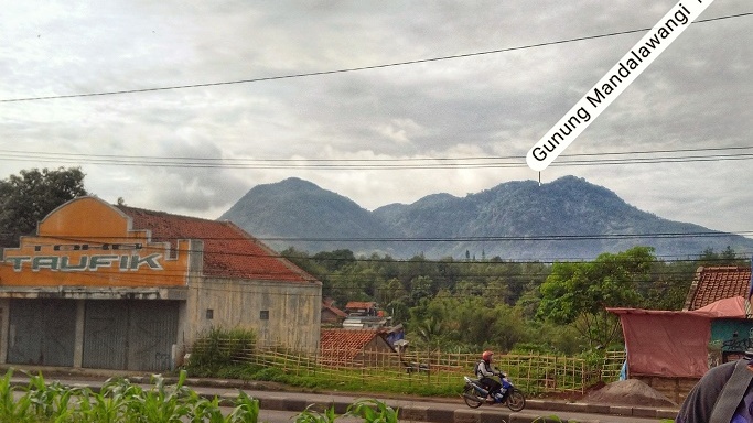
BandungBergerak.id – We can see a mountain with moderate elevation when passing along Nagreg Highway, namely Mount Mandalawangi. It's located on the southern side of the road connecting Bandung and Garut.
The elevation of this mountain is 1,640 meters above sea level (masl), according to the Indonesian Topographic Map (RBI) published by the Geospatial Information Agency, sheet 128-643 edition I - 2001, map title Majalaya scale 1: 25,000. However, among climbers, the height is more commonly known as 1,650 masl.
Location and Access
Administratively, Mount Mandalawangi is located on the border between Bandung Regency and Garut Regency. The northern slopes and foothills are situated in Mandalawangi Village and Bojong Village, Cicalengka Subdistrict, Bandung Regency. Meanwhile, the southern slopes and foothills tend to extend into the area of Karangtengah Village, Karangmulya Village, and Mandalasari Village, Kadungora Subdistrict, Garut Regency.
To reach this mountain's location, we can travel from the Cibiru roundabout, the boundary of Bandung City, to the east. On the southern side of Nagreg Highway, we will find Citaman Road, which turns towards the foothills of Mount Mandalawangi, precisely in Cibisoro Village, Bojong Village. The landmark for turning off the highway is the Headquarters of Yonif Linud/Para Raider 333 Cicalengka.
Batalyon Infanteri Para Raider 33/Tri Dharma (abbreviated Yonif Para Raider 330/Tri Dharma) is one of the three Para Raider battalions under the umbrella of the 17th/Kujang 1 Para Raider Infantry Brigade, 1st/Kostrad Infantry Division. The other two battalions are Yonif Para Raider 328/Dirgahayu located in Cilodong, Depok, and Yonif Para Raider 305/Tengkorak located in Karawang.
Climbing to one of the peaks of Mount Mandalawangi, we will come across a monument with the emblem of Battalion Kujang 1. This peak is also known as Puncak Kujang.

Baca Juga: MOUNTAINS IN GREATER BANDUNG: Mount Pangparang, the Tallest Mountain in East Bandung
MOUNTAINS IN GREATER BANDUNG: Mount Puncak Besar, the Tallest Peak in the Malabar Mountains
MOUNTAINS IN GREATER BANDUNG: Mount Burangrang, Silent Witness to the History of Mount Sunda Purba and the Saung Agung Kingdom
Toponymy and Myth
The name Mount Mandalawangi might not be as well-known. Unlike other mountains in the Greater Bandung Area, such as Mount Tangkubanparahu, Mount Burangrang, Mount Malabar, Mount Patuha, Mount Manglayang, and others. In fact, when mentioning Mandalawangi, climbers are more likely to recognize it as a valley at the peak of Mount Pangrango.
The same goes for the toponym or the origin of its name. It's quite difficult to find sources that can definitively answer this question.
One version suggests that the name Mandalawangi is related to the legendary story of the Majalaya region, which also has connections to the Rajamandala region. The Rajamandala being mentioned lies on the border between West Bandung Regency and Cianjur Regency.
Legend has it that there was once a kingdom ruled by a king named King Mandala. King Mandala had nine sons and one daughter. The eldest was named Mandalawangi, followed by Mandalagiri, Mandalacipta, Mandalarasa, Mandalajati, Mandalabraja, Mandalaseta, Mandaladenta, Mandalaraga, and the youngest, was named Princess Mandalasari.
When Mandalasari was still a baby, she was reluctantly abandoned in the middle of the forest to bring healing to the people in the kingdom who were suffering from disease and to end a prolonged drought. In the forest, Mandalasari was found by Ki Dasta. As she was found among the trees, Ki Dasta named her Sela Asih, commonly called Princess Selasih.
As Princess Selasih grew into a beautiful young woman, she met a handsome, powerful, and charming young man. They intended to marry, but it turned out that the young man was Mandalawangi, her own elder brother.
In short, they didn't get married and were transformed into mountains. Princess Selasih became Mount Selasih, while her brother became Mount Mandalawangi. Mount Selasih is not far from Mount Mandalawangi, specifically in the southwestern direction toward the Majalaya area.
Another version of the origin of the name Mount Mandalawangi from its connection to a kingdom centered around Nagreg, known as the Kéndan Kingdom. This kingdom is believed to have flourished in the sixth century CE, or during the twilight of the Tarumanagara Kingdom, and is considered to be the precursor to the Galuh Kingdom.
Referring to various historical sources, at that time there were two areas known for social activities, kabuyutan and kamandalaan. Kabuyutan was a place for spiritual and religious activities, such as praying and learning about religion or spiritual beliefs as they were understood at that time. On the other hand, kamandalaan was a place for learning worldly knowledge, such as statecraft and martial arts.
Both kabuyutan and kamandalaan were usually located in areas near mountains. During the Kéndan Kingdom, the Kabuyutan area was known to be around Mount Manglayang. Meanwhile, the Kamandalaan area was what later became known as Mount Mandalawangi, meaning a fragrant place of knowledge.
The more accurate origin of these two versions still remains to be explored further. It's also possible that there are other versions beyond the two mentioned here, which remain largely unknown.
Mount Mandalawangi indeed still holds many mysteries. Including the number of its peaks. At a glance from Nagreg Highway, the mountain seems to have five peaks, but if seen from Kadungora in Garut, the number of peaks appears different. According to local residents, this mountain even has 25 peaks. Some of the peaks are believed to be invisible, only seen and found by those who possess the ability, and occasionally by ordinary people.
In addition to myths about the number of its peaks, there is also the myth of an old woman who sometimes appears in the forests of Mount Mandalawangi. There was a story about local people who got lost and were guided back home by a mysterious old woman.
Equally intriguing is the myth of the headless horse rider on this mountain. Supposedly, the headless horse rider is also present on its neighboring mountain, Mount Kaledong. Furthermore, there's the myth of Nini Ranteng's meditation site, which is believed to exist in two places: the main peak and the southwestern side of Puncak Kujang.
Another myth circulating among the community about this mountain is to avoid asking for directions frequently when in the forest.

When climbing this mountain, it's recommended to be accompanied by someone who has climbed it before or to be guided by locals. The most impressive time to visit is during the rainy season. Choosing the route from Kampung Cibisoro, you will come across a clear small river. These small rivers form several interesting small waterfalls. During the dry season, these small rivers appear like scattered rocky paths.
Vehicles can be left at local homes. Therefore, there's no need to worry if you plan to hike all day round-trip or to hike while camping. One place that is often used to park their vehicles is Kang Iing's place, not far from Nurul Iman Mosque at the end of the village. It's important to report to or seek permission from the local community before starting your climb.
From the end of Cibisoro Village, the climb begins by passing through local plantations and charming bamboo groves. Afterward, you'll walk alongside a clear small river, which can only be fully enjoyed during the rainy season.
Another highlight of this route is the presence of large rocks and trees. It's quite enjoyable to discover that even this tiny mountain, boasts exceptional natural richness. Along the journey, your sight will be refreshed by the natural greenery.
The first peak commonly reached via this route is the shadow peak, a relatively flat area. From here, you can either proceed directly to the main peak, known as Nini Ranteng Peak, or head towards the Western Peak, where the Kujang monument is located as described earlier.
In addition to the Cibisoro Village route, there's also the Cijapati route. This route is better organized, featuring a basecamp for starting your climb. It's located in Pabrik Village, Kadungora Subdistrict, Garut Regency.
Unlike the Cibisoro Village route, hiking through the Cijapati route will be better if not done during the rainy season. The peaks on this route are more open, allowing for better views of the surrounding mountains. The relatively steep ascent is also easier to navigate when the trail isn't slippery or wet.
Another route can be taken through Mount Buleud to the west of Mount Mandalawangi.
As a mountain with pristine forest conditions and large trees with robust roots, Mount Mandalawangi plays a crucial role as a source and reservoir of water for both Bandung Regency and Garut Regency. There are dozens of springs in the mountain area.
The tourism potential of this region is significant and continually growing, including opportunities for both natural and religious tourism. For instance, the potential of the Cibuniracun waterfall in Mandalagiri. While the name might sound eerie, — racun means poison — it's becoming known as a tourist destination, especially for religious tourists.
The land and natural conditions at the foothill of Mount Mandalawangi are also suitable for planting productive hardwood trees, suited better than vegetable crops. The government has allowed locals to manage these areas, of course, under the coordination of relevant authorities and the Lembaga Masyarakat Desa Hutan (LMDH) through the Pengelolaan Hutan Bersama Masyarakat (PHBM) program that needs to be established first.
* Translated from this article by Zelika Salsabila Insyra.