MOUNTAINS IN GREATER BANDUNG: Mount Pangparang, the Tallest Mountain in East Bandung
In the 19th century, the area of Mount Pangparang was turned into a quinine plantation by the Dutch.
Penulis Gan Gan Jatnika1 Oktober 2023
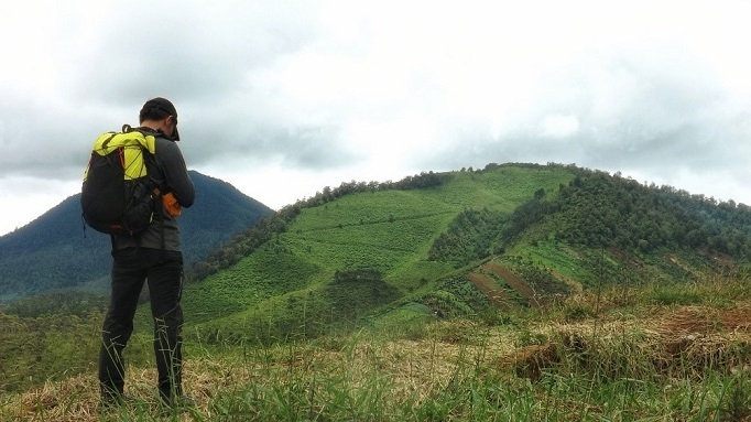
BandungBergerak.id - Bandung dilingkung gunung (Bandung surrounded by mountains), and these hundreds of mountains are spread almost evenly throughout the Greater Bandung area. Similarly, the eastern Bandung area has a fairly large number of mountains. One of them is Mount Pangparang.
For the people of Bandung, the eastern region is associated with areas such as Ujung Berung, Cibiru, Cilengkrang, Cileunyi, Jatinangor, Tanjungsari, Rancaekek, Nagreg, Cikancung, Cicalengka, Cipacing, Sapan, and their surroundings. Some parts of these areas also extend into the Sumedang Regency.
Among the mountains in the eastern Bandung region are Mount Manglayang, Mount Pacet, Mount Palasari, Mount Pangparang, Mount Jambu, Mount Geulis, Mount Mandalawangi, Mount Masigit, Mount Pangradinan, Mount Kerenceng, Mount Kareumbi, Mount Bukitjarian, and Mount Buyung.
Among these many mountains, which one has the highest peak? The answer is Mount Pangparang.
According to the Rupa Bumi Indonesia (RBI) edition I-2001 at a scale of 1:25,000, published by the Geospatial Information Agency, the peak of Mount Pangparang reaches an elevation of 1,957 meters above sea level (masl), nearly reaching 2,000 masl.

The name Mount Pangparang originates from the legend of Sangkuriang. Sangkuriang used a machete to cut down a tree that would be used to build a boat, as required by Nyai Dayang Sumbi. After using the machete, he threw it away, and over time, it transformed into a mountain, which is now known as Mount Pangparang.
Not far from Mount Pangparang, there's Mount Bukittunggul. According to the myth, this mountain is the result of the tree trunk that Sangkuriang had cut down. There's also Mount Kasur to the south of Mount Pangparang. According to locals from Ciangkeb Village, at the foot of Mount Kasur, Mount Kasur is also part of the legend of Sangkuriang.
Another version suggests that the tallest mountain in the eastern Bandung area is named Mount Pangparang due to the abundance of Pangparang trees growing here.
In the 19th century, during the colonial period, the area of Mount Pangparang was turned into a quinine plantation by the Dutch. According to records from the Balai Arkeologi Jawa Barat (West Java Archaeological Center), the opening and planting of the Pangparang quinine plantation began in May 1884.
Around the same time, the opening and planting of several other plantations in the area began as well. These plantations included the Panglipur Galih (Pangli) quinine plantation, Mount Kasur, Gegersunten, Sukamanah, and the Cisarua quinine plantation.
In 1912, these six plantations merged under the name Bukittunggul quinine plantation.
For the plantation workers, housing was provided on the slopes and foothills of Mount Pangparang. The villages were known as Pangli Village and Mount Kasur Village. To this day, both villages still exist.
Baca Juga: MOUNTAINS IN GREATER BANDUNG: Mount Geulis Manggahang, the Highest Peak of the Baleendah Barisan Hills
MOUNTAINS IN GREATER BANDUNG: Mount Tangkuban Parahu, The Legend of Sangkuriang and its Geological History
MOUNTAINS IN GREATER BANDUNG: Mount Wayang Pangalengan with the Charm of Situ Cisanti and the Wayang Crater on Its Two Slopes
Location and Access
Administratively, Mount Pangparang is located on the border between the Bandung Regency and the Sumedang Regency. The western slopes and foothills are part of the Cipanjalu Village in the Cilengkrang Subdistrict, Bandung Regency. The eastern slopes and foothills fall within the Genteng Village in the Sukasari Subdistrict, Sumedang Regency. The peak itself is within the Sumedang Regency.
To reach Mount Pangparang, there are two main routes. First, from the north through the Cibodas route in Lembang. Once at the end of Gegersunten Village, take a southern turn towards Palintang.
The second route is accessed from the south, through the Ujung Berung town square. The distance from Ujung Berung's town square is relatively shorter compared to the Cibodas route.
The road to Mount Pangparang goes through Cigending Street located behind or to the north of Ujung Berung's town square. Simply follow this road until you reach a small shop at the end of a field. This field is called Mount Kasur Field, in accordance with the name of the village, Mount Kasur Village.
If you intend to climb to the peak of Mount Pangparang, you can leave your vehicle at this shop. Similarly, if you plan to camp on the mountain, you can leave your vehicle at a resident's house. Details of the hiking trails can be asked to stall owners or other residents.

Climbing at Mount Pangparang is unlike other mountains in the Greater Bandung area. Typically, when climbing mountains around the Greater Bandung region, steep ascents that demand physical effort are common. However, on Mount Pangparang, such steep climbs are almost non-existent It seems that this mountain is suitable for climbers who are less familiar with climbs. The path is gradual and winding. In fact, in certain parts of the path, broad rocky roads are visible.
It's likely that in the past, the path we traverse was originally a vehicle route used for transporting plantation yields from the slopes and the vicinity of Mount Pangparang's peak, thus designed to be less steep.
The peak of Mount Pangparang is lush and covered with trees. It's not an open area where you can witness extensive landscapes, unlike the peaks of other mountains. This could explain why not many climbers are drawn to this mountain.
Nonetheless, not far from the peak, there's a large open grass field that can accommodate about 10 tents with a 4-person capacity. In this area, there's a box-shaped well with a wall-like structure around it. The function of this well is uncertain. It's in this spot that your eyes are refreshed with a more expansive view.
Apart from the main climbing route mentioned earlier, there are other appealing alternative routes. The western route introduces steep inclines and dense tall grass before reaching the peak. Along this route, you'll also encounter a large puspa tree.
Another path is from the north, starting from Pangli Village. This route takes you to a small yet beautiful lake. This lake is known as Urug Lake, although it's also sometimes referred to by a rather eerie name, Tengkorak Lake.
Current Condition
While Mount Pangparang used to be a quinine plantation, its current condition has changed. Parts of it have transformed into vegetable and coffee plantations. This change is attributed to the decreasing profitability of the quinine plant and its products in the market, compared to the past.
* Translated from this article by Zelika Salsabila Insyra.