MOUNTAINS IN GREATER BANDUNG: Mount Geulis Manggahang, the Highest Peak of the Baleendah Barisan Hills
From the peak of Mount Geulis Manggahang in Baleendah, one can relish the view of the Bandung basin. Unfortunately, the condition of this area is increasingly concer
Penulis Gan Gan Jatnika19 September 2023
BandungBergerak.id - "Bandung dilingkung gunung (Bandung surrounded by mountains)" is a phrase that has been popular for quite some time. Hundreds of mountains in the north, east, west, and south act as natural fortresses guarding the Greater Bandung region. In the north there is Mount Tangkuban Parahu, in the east there are Mount Manglayang and Mount Mandalawangi, in the south there are Mount Malabar and Mount Patuha, and in the west is a cluster of the Soreang Mountains, Cililin, as well as the Padalarang Karst that extending and fortifying the area.
If someone wishes to observe and enjoy the natural beauty of the Greater Bandung mountains, where should they go? Is there any mountain where we can see other mountains in the Greater Bandung with a 360-degree view?
Baca Juga: MOUNTAINS IN GREATER BANDUNG: Mount Sangar Arjasari, Small and Beautiful at the Foot of the Malabar Mountains
MOUNTAINS IN GREATER BANDUNG: Mount Manglayang, Blessings of Sanctity and Beauty that Towering in Eastern Bandung
MOUNTAINS IN GREATER BANDUNG: Mount Putri Lembang, the Myth of Dayang Sumbi and the History of the Dutch Fort
The Towering Mount Geulis
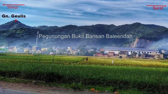
In the old map of Hoogvlakte van Bandoeng, published by Hovic in 1920, there are noted 37 mountains. One mountain stands out within this formation, marked with a red circle and arrows pointing in various directions. Most of these mountains are situated in the Baleendah district, and geologists refer to them as the Baleendah Vulcanology (BV), which spans over 6 kilometers horizontally.
While geologists refer to it as Baleendah Vulcanology, outdoor enthusiasts, particularly mountain climbers, have a different name for it – the Baleendah Bukit Barisan (BBB) or Baleendah Barisan Hills.
Measured in a straight horizontal line, the expanse of the Baleendah Barisan Hills is over 6 kilometers. However, the distance covered by foot would be greater, starting from Mount Karikil in the west to Mount Bukitcula in the east. Climbing and descending its peaks, winding left and right, following the slopes and ridges of the mountains, would cover a distance of over 20 kilometers.
Among these mountains, Mount Geulis boasts the highest peak. According to Rupa Bumi Indonesia (RBI) issued by the Geospatial Information Agency, it reached 1,154 meters above sea level (masl) from a scale of 1:25.000.
Therefore, Mount Geulis becomes a suitable location for observing the panoramic view of the mountains that surround Greater Bandung. Additionally, this mountain's peak offers a splendid view of the Bandung basin, which was once a prehistoric lake.
When the Greater Bandung area was still a lake, the Baleendah mountains formed its southern boundary. The foothills of these mountains were once the lake's shores, akin to a beach along the extensive Danau Bandung Purba.

Origin of Mount Geulis Name
The name Mount Geulis Manggahang is derived from several versions, but they all share a similar story – a tale of a "geulis" (beautiful) princess and a young man who was smitten and sought her hand in marriage. Unfortunately, the proposal of this young man was rejected by the princess, despite his offerings of various gifts. These ranged from cooking utensils and food supplies to even an elephant.
The oldest version of the origin of the name Mount Geulis dates back to the 1970s, as was shared by a martial arts teacher from Pamucatan Village, Arjasari, by the name of the late Abah Ratmaja. He recounted that there was once a young man from the Kingdom of Daha (the kingdom's location remains unknown) who wished to court a beautiful princess. This princess resided in Lebakwangi Village, still within the Arjasari region. In short, his proposal was declined, and the offered items were abandoned. These items subsequently transformed into mountains in that area. These include Mount Pabeasan, Mount Parabot, Pasir Jampana, Pasir Salam, Pasir Wilis, Kancahnangkub, Batumunding, and more. As for the princess, she turned into a mountain, later named Mount Geulis.
Another version comes from the residents around Manggahang Village. The tale tells of a young man who wished to propose to a beautiful princess. The young man's name was Bakit Culah, while the princess was known as Si Geulis. Fearing that another suitor might beat him to it, and feeling confident that his proposal would be accepted, Bakit Culah boldly proposed. He came bearing various gifts, including an elephant.
As his proposal was declined, Bakit Culah kicked away all the offerings. These objects then transformed into mountains, including Mount Gajahngambung, which was the manifestation of the elephant he brought along with his proposal. The young man himself also turned into a mountain named Mount Bukitcula, while the princess became Mount Geulis.
Yet another version narrates that Mount Geulis is the embodiment of a beloved beautiful princess, a pair of grandparents’ favorites. Eventually, the princess transformed into Mount Geulis, with her grandmother becoming Mount Nini, and her grandfather becoming Mount Pipisan. These two mountains are situated not far away, to the east of Mount Geulis.
Adventure Tourism Destinations
With the growing popularity of adventure tourism or outdoor activities nowadays, Mount Geulis has become a favored climbing destination. Its relatively short journey and ease of access from various directions, combined with its captivating peak views, have contributed to its increasing renown.
There are three routes that adventurers and climbers can take. The first route on the southern side can be accessed from Mount Pabeasan, Arjasari. The second route on the eastern side can be reached from Mount Pipisan or from Kampung Pacet, Pinggirsari. The third route on the western side can be taken from Manggahang Village or by taking a more distant path from Mount Koromong.
The ascent takes only a short time, around 1-2 hours, although there are moderately challenging inclines that can be tiring. Another challenge is the heat of the sun, especially during the daytime. Along the journey, dense forests are not encountered. At most, there are clusters of bamboo and calliandra trees with their distinctive red blossoms, lining the ascent path and welcoming the explorers.
Upon reaching the peak, we will be treated to captivating views. If we choose to hike to enjoy the sunrise or sunset moments, then this mountain is the right choice. There are two tombs with buildings made of walls that are now in ruins. Information about these tombs or historical sites is not yet very clear, as there are various versions.

Concerning Condition
The formation of the Baleendah Barisan Hills dates back a long time, approximately 3.5 million years ago. According to geological experts, the early mountains that emerged in the Greater Bandung region were the Soreang and Lagadar mountains, followed by the Baleendah and Malabar mountains. Then came the mountains in northern Bandung.
The rocks in the Baleendah mountains consist of intrusive rock types, which form due to the solidification of magma beneath the earth's surface, subsequently surfacing. As a result, this area is highly favorable for mining activities.
Truthfully, the preservation condition of the Baleendah area is quite concerning. The habitat for mountain plant species is dwindling, and dense forests are scarce. Sand and rock mining, coupled with increasing urban settlements, have given rise to significant challenges.
Therefore, small mountains are disappearing one by one. Individual ownership of land in the mountainous region leads to changes in forest and mountain functions difficult to prevent. Not all landowners are indifferent to environmental preservation, as some continue to make efforts to ensure that future generations can enjoy the beauty of the Baleendah Barisan Hills.
* Translated from this article by Zelika Salsabila Insyra.