MOUNTAINS IN GREATER BANDUNG: Mount Burangrang, Silent Witness to the History of Mount Sunda Purba and the Saung Agung Kingdom
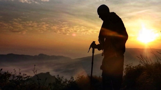
Mount Burangrang is one of the most well-known and favorite mountains among hikers in the Greater Bandung Area due to the stunning views from its peak.
Penulis Gan Gan Jatnika3 November 2023
BandungBergerak.id - Mount Burangrang, administratively located on the border between West Bandung Regency and Purwakarta Regency, is easily recognizable from various directions due to its towering height. Even from Bandung city, Mount Burangrang is visible, provided the weather conditions are favorable. It's located near Mount Tangkubanparahu.
Part of Mount Burangrang's area, especially the western side in Purwakarta, is designated as a nature reserve. Climbing to the mountain's peak is best done by choosing routes outside the nature reserve area.
According to the Rupa Bumi Indonesia (RBI) map, sheet Cimahi, published by the Geospatial Information Agency in the 2001 edition at a scale of 1:25,000, Mount Burangrang's elevation is stated as 2,064 meters above sea level (masl), but among hikers, its elevation of 2,050 masl is more commonly known.
Origin of Name and History
The name Mount Burangrang has been known for a long time, even before Europeans arrived and occupied the Nusantara. Its name can be found in the Bujangga Manik manuscript.
As known, Bujangga Manik was a young noble from the Kingdom of Pakuan who embarked on twice journeys around Java Island around the 1500s CE. The record of his travels has been preserved from 1627 to the present day with the manuscript code MS. Jav.b.3 (R), held in the Bodleian Library at the University of Oxford, England.
In his writings, Bujangga Manik stated:
...
Itu Tangkuban Parahu, (That's Tangkuban Parahu,)
tanggeran na Gunung Wangi. (it's the boundary of Mount Wangi.)
Itu ta gunung Marucung, ta(ng)geran na Sri Manggala. (That's Mount Marucung, the boundary of Sri Manggala.)
Itu ta bukit Burangrang, (That's the hill Burangrang,)
ta(ng)eran na Saung Agung. (the boundary of Saung Agung.)
...
In this manuscript, it's mentioned that at the foothills of Mount Burangrang, there used to be markers or boundary stones of a kingdom, namely the Saung Agung Kingdom.
According to historians, the Saung Agung Kingdom was located in the eastern part of the Purwakarta area, and a portion of its territory was situated on the slopes of Mount Burangrang, specifically in the present-day area of Wanayasa. The defeat of Saung Agung by the Cirebon Sultanate led to the collapse of the kingdom by the end of the 1600s, so the name was changed to Wanayasa.
Regarding the origin of the name Mount Burangrang itself, there are several versions. Some believe that the name "Burangrang" is derived from the word "jarang" or "carang," referring to the sparsely spaced ravines or gullies on its slopes.
Another more popular version suggests that the name "Burangrang" comes from the word "rangrang," meaning branches or twigs of trees. Legend has it that when Sangkuriang crafted a boat from wood, the branches or "rangrang" of the wood transformed into a mountain on the west side of Mount Tangkubanparahu. This mountain was subsequently named Mount Burangrang.
Baca Juga: MOUNTAINS IN GREATER BANDUNG: Mount Wayang Pangalengan with the Charm of Situ Cisanti and the Wayang Crater on Its Two Slopes
MOUNTAINS IN GREATER BANDUNG: Mount Pangparang, the Tallest Mountain in East Bandung
MOUNTAINS IN GREATER BANDUNG: Mount Puncak Besar, the Tallest Peak in the Malabar Mountains
Climbing Routes
To climb Mount Burangrang, several routes are available that avoid passing through the nature reserve area. For instance, the Tanjakan Mentari Route, Komando Route, and Legokhaji Route.
Among these routes, the Legokhaji Route is the most commonly taken, and it can be easily accessed from Bandung City. It can be reached through the Cimahi highway, then turn to the north from Cimahi Square and continue until the location of the Sekolah Polisi Negara (SPN) in Cisarua.
Similarly, from Ledeng or Lembang directions, you can navigate your way to the same SPN Cisarua location. From SPN Cisarua, we continue our journey through the Barukai market, then head to the Legokhaji hiking base camp.
According to local residents who sell in the basecamp area, the area is called Legokhaji because it's located in a "legok" or valley that was once a village, with an elder named Eyang Haji Darussalam. The village was eventually taken over by the Forestry Service, and its residents were relocated to a better housing area not far from the original village location.
If you choose for the Legokhaji climbing route, you can park your vehicle at the base camp. The parking fee is 10,000 Indonesian rupiahs per motorcycle, and there's an entrance fee of 10,000 rupiahs per person.
The journey from the base camp to the peak usually takes about 3-4 hours. During the hike, you'll encounter four checkpoints. The trail is relatively flat from checkpoint 1 to 2. While from checkpoints 3 to 4, the path has been continuously uphill.
However, any exhaustion and fatigue from the seemingly endless uphill trek will vanish when rewarded with a joyous feeling. The hikers' efforts are rewarded with a beautiful panorama. If you turn your gaze to the south, you'll see the city of Bandung and Cimahi.

The History of Mount Sunda Purba
Urban settlements are clearly visible from the peak. Turning east, you'll behold the caldera and the walls formed by the eruption of Mount Sunda Purba millions of years ago.
The term "caldera" refers to a hole resulting from a volcanic eruption, typically resembling a large bowl or kettle with a diameter of more than 2 kilometers. If the diameter of the eruption hole is less than 2 kilometers, it's referred to as a crater.
Before erupting, Mount Sunda Purba was estimated to have an elevation exceeding 4,000 masl, possibly making it the tallest mountain on Java Island at the time. After its eruption, Mount Sunda Purba left behind a caldera with steep walls on its northern to western sides, and open walls on its eastern to southeastern sides. In the center of the caldera, a new mountain grew, known as Mount Tangkubanparahu.
Mount Burangrang itself was formed at the same time as the birth of Mount Sunda Purba, making it older than Mount Tangkubanparahu. In simpler terms, Mount Burangrang can be considered the "uncle" of Mount Tangkubanparahu.
Further evidence supporting Mount Burangrang's older age than Mount Tangkubanparahu is the abundance of ravines with steeper and deeper slopes. This is due to the ongoing volcanic and land movement activities that have occurred on its slopes and peak for a very long time.
Myths and Tragedies That Have Occured
A mountain, shrouded in dense forest and ancient myths, undoubtedly holds many stories. The experiences of hikers and locals who have visited the area are varied.
A well-known myth about Mount Burangrang is the existence of a "Bermuda Triangle" within its mountainous region. This area is located on the western slope or around Mount Gedugan, which later became the origin of its name "Gedugan Triangle.”
Another myth relates to the presence of Mount Sunda Purba, which is believed to still exist invisibly. This unseen Mount Sunda Purba stands between Mount Burangrang and the western side of Mount Tangkubanparahu.
These myths are often linked to the disappearance of hikers and plane crashes around Mount Burangrang.
Records indeed show that several planes have crashed here. On March 11, 1947, a Dakota plane crashed. In 1986, a light transport plane Dornier crashed. In February 2001, a helicopter belonging to Perhutani crashed in the Cihanjawar block and was only found after a 13-day search. In 2011, a Cessna plane also crashed and took several days to be located.
Naturally, the crashes of these planes are more logically associated with Mount Burangrang's often foggy conditions and strong winds.

Other Potentials and Challenges
Besides the natural tourism potential of climbing to Mount Burangrang's peak, the Legokhaji area is home to other attractions, such as the Cipalasari Waterfall.
Local residents have creatively capitalized on this opportunity. For example, open souvenir shops or gift shops at the climbing base camp; offering stickers, keychains, and other craft items as souvenirs after climbing.
The agriculture and livestock sectors also serve as the main sources of income for the residents. Residents manage tens of hectares of vegetable farms, with their produce transported to markets in the nearby areas and even further away.
Likewise, cattle farms are common in the area. The abundance of natural livestock feed, such as grass and other plants, allows local farmers to produce fresh and high-quality milk.
However, these activities are not always safe. The potential risks of natural disasters must be continuously monitored. Landslides, earthquakes, and ground movements could occur, especially during the rainy season.
Those who hike Mount Burangrang during the rainy season should be cautious, as they are likely to encounter very slippery trails. Therefore, prepare thoroughly and carefully for the climb. If you face difficulties, don't hesitate to seek assistance from local residents or caretakers. These people are friendly and always ready to help.
* Translated from this article by Zelika Salsabila Insyra.